Earth Science
-
Earth Science
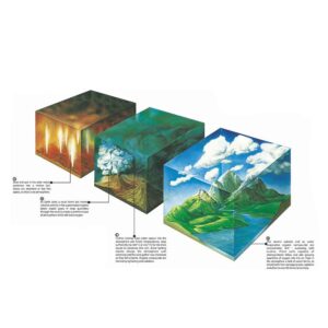
Origin of the Earth
A model illustrating the stages of Earth’s formation typically begins with the primordial accretion of dust and gas around 4.6 billion years ago, leading to the formation of a molten planet. As the planet cooled, a solid crust formed, followed by the development of oceans and the early atmosphere. The model may then depict the formation of the first continents through volcanic activity and tectonic processes. Over time, the gradual development of complex life forms and the stabilization of climate conditions contributed to the Earth as we know it today.
BG19032 -
Earth Science
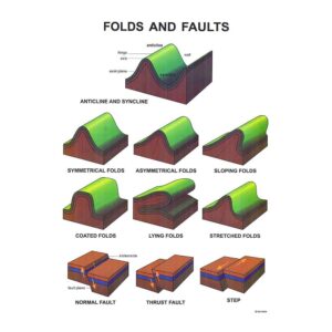
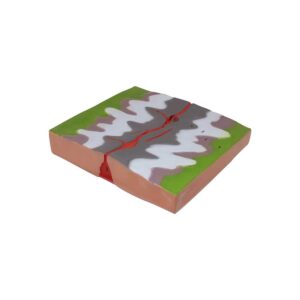
Folds & Faults
A model depicting folds and faults in land illustrates how tectonic forces shape the Earth’s crust. Folds, such as anticlines and synclines, form when rock layers are compressed and bend without breaking. Faults, including normal, reverse, and strike-slip faults, occur when rocks fracture and slip due to tectonic stress. The model helps visualize these geological processes and their effects on landscapes, showing how mountain ranges, valleys, and other landforms are created and modified over time.
BG19033 -
Earth Science
Rock Cycle Model
A model depicting coastal and mountain terrain in natural color relief with a cross-section diagram of a typical volcano, sized 60×45 cm, provides a detailed, three-dimensional view of these geological features. The volcano cross-section reveals the internal structure, including the magma chamber, volcanic conduit, and crater, with surrounding layers of volcanic rock. This model offers an educational perspective on how coastal and mountain landscapes interact with volcanic activity.
BG19045 -
Earth Science
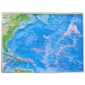
Ocean Features Model
A 45×60 cm relief map of the North Atlantic Ocean, highlighting a typical section of the ocean floor, provides a clear and detailed view of key oceanic features. This map includes prominent features such as mid-ocean ridges, abyssal plains, and deep-sea trenches, making it easy to identify and study major oceanic structures. Accompanied by a comprehensive lesson plan, the map serves as an educational tool for understanding ocean floor topography and the geological processes that shape it. The lesson plan helps guide instruction on the formation and significance of these features
BG19046 -
Earth Science
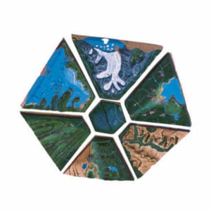
Land form Model
The 90×90 cm model, composed of eight interconnected landform sections, offers a comprehensive investigation into diverse geographical and geological features. This continuous model displays a range of terrains including mountains, lakes, rivers, deserts, glaciers, coastlines, canyons, and cultural landmarks. Each section seamlessly connects to create a cohesive representation of Earth’s varied landscapes. Accompanied by an informative lesson plan, the model provides an engaging educational tool for studying the formation and interaction of these landforms, and their impact on human culture and environment.
BG19048 -
Earth Science
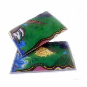
Comparative Terrain Model
The set of two 45×60 cm landform models features overlays that represent ancient mountain formations, which can be removed to compare with the base models showing their evolved state over millions of years. These models include cross-sections that illustrate various mountain types such as volcanic, fault-block, glaciated domes, and folded mountains. This interactive design allows for a clear visual comparison of geological changes over time. Accompanied by a detailed lesson plan, the models offer an effective educational resource for understanding the dynamic processes that shape mountain landscapes and their historical transformations.
BG19050 -
Earth Science
Water Cycle Model
Creative model For Student to duplicate the individual processes of the water cycle (evaporation, condensation & precipitation). With set of ten coloured study cards for students understanding of the water cycle & awareness of the various states of water. Requires a heat lamp, not included.
BG19052 -
Earth Science
Water Table Model
This model illustrates the upper level of an underground surface where soil or rock is permanently saturated with water, known as the water table. It clearly depicts how the water table separates the saturated underground water zone from the overlying capillary fringe, or zone of aeration.This visual representation helps in understanding groundwater distribution and the dynamics of water flow within different subsurface layers.
BG19055 -
Earth Science
Open Pit Mine Model
The open pit mine model provides a detailed representation of a large, excavation-based mining operation. It showcases the various stages of mining, from the initial removal of surface layers to the extraction of valuable minerals or ores from the underlying rock.
BG19058 -
Earth Science
Underground Mine Model
This model demonstrates underground mining techniques used when an ore body is located at significant depths below the surface. The model highlights various underground mining methods, such as shaft mining and sublevel stopping, showing how miners create tunnels and shafts to access and extract the ore. It also emphasizes the engineering challenges and safety considerations involved in reaching and retrieving valuable resources from deep underground.
BG19060 -
Earth Science
The Lava Legacy Plateau (Volcanic Action)
This model demonstrates lava plateau formation, highlighting lava layering from multiple eruptions, fissures as lava pathways, and the magma source. It features fissures, molten lava, cinder cones, and lava layers (new, older, oldest), alongside a plain and magma chamber, offering a detailed view of volcanic processes and geological stratigraphy typical of a lava plateau. Highly featured model with size of 40 x 35cm
BG19086A -
Earth Science
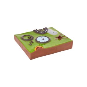
Caldera Chronicles The Majesty of Fire and Time (Volcanic Action)
This model presents an educational journey through the formation and evolution of a caldera, showcasing associated volcanic features such as a crater lake, volcanic neck, cinder cones, ring dykes, and laccoliths. It captures the essence of volcanic activity, from the explosive events that create calderas to the erosive processes that expose the deep structures of ancient volcanoes.
BG19086B -
Earth Science
Riverscape Rhythms The Dance of Water And Sediment (River Action)
This model encapsulates the journey of water from steep mountain fronts, through the formation of an alluvial fan, transitioning into a braided stream system across a plain. It highlights the interplay between rapid water flow, sediment transport, and deposition processes that shape these distinctive geological features.
BG19087A -
Earth Science
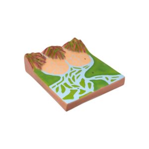
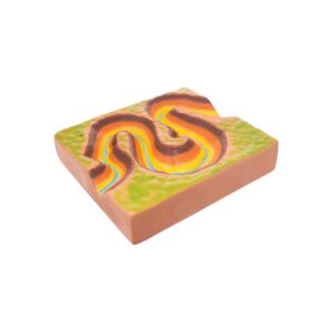
Meandering Majesty The Sculpted Paths of Time (River Action)
This model captures the essence of a river as it carves its way through the landscape, creating entrenched or incised meanders and ultimately sculpting deep canyons. It highlights the contrast between the youthful meandering rivers found on plains and the mature, deeply incised meanders that cut through elevated terrains or plateaus, demonstrating the river’s power to shape the earth.
BG19087B -
Earth Science
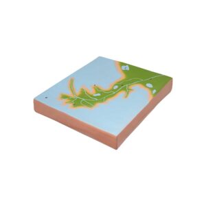
Delta Whispers The Fingers of Life (Delta Formation)
This model presents the dynamic environment of a bird’s foot delta, emphasizing the processes of sediment deposition that lead to its formation and the rich ecosystems it supports. It captures the moment where the river, carrying sediments from its journey across the continent, meets the sea, and its water slows down, spreading out into several distributaries that deposit silt and form new land.
BG19088A -
Earth Science
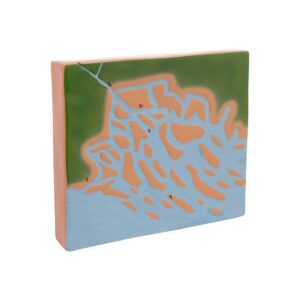
Tides of Transformation the Delta’s Dance (Delta Formation)
The model depicts a high-destructive-tide-dominated delta, which is characterized by strong tidal currents that influence the formation and reshaping of its landscape. This type of delta experiences significant erosion and deposition due to the powerful tidal forces, leading to unique features such as prominent tidal channels, sand bars, and a flat delta plain.
BG19088B -
Earth Science
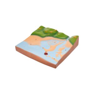
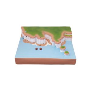
Sands of Serenity Coastal Creations Tapestry (Sea Section)
The Sea Section A Model offers a detailed representation of depositional landforms found along coastal environments, showcasing estuarine mud-flats, lagoons, offshore sand bars, tombolos, and sand dunes within a compact size of 40 x 35 cm. Crafted with meticulous attention to detail, this model accurately depicts the dynamic processes of coastal sedimentation and land form formation.
BG19089A -
Earth Science
Whispering Coasts Echoes of Erosion (Sea Section)
The Sea Section-B Model offers a detailed representation of erosional landforms found along coastal environments, featuring blowholes, bedding planes, remnants of former headlands, sea cliffs, and stumps within a compact size of 40 x 35 cm. Crafted to meticulous detail, this model accurately depicts the dynamic processes of coastal erosion and land form evolution.
BG19089B